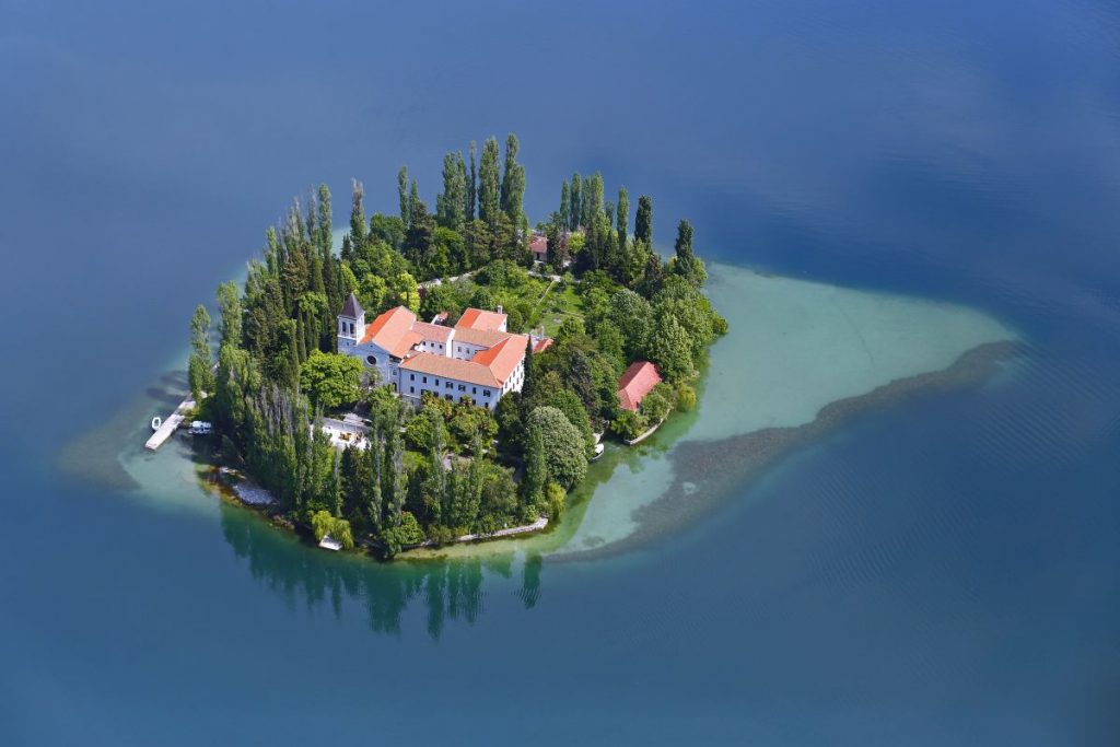
Loading
admin

Krka National Park

Krka National Park

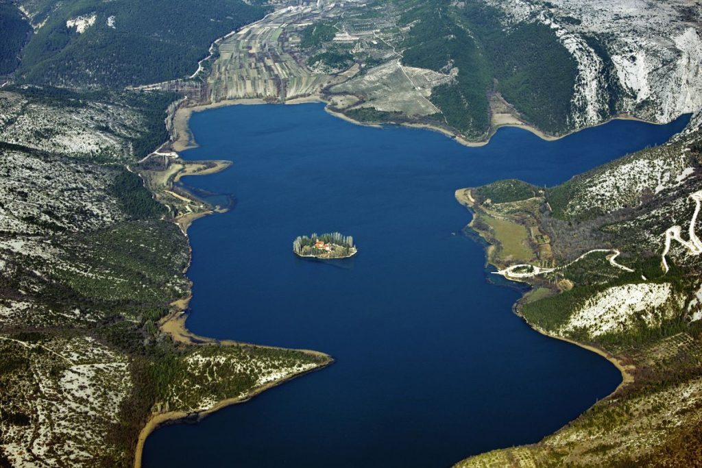
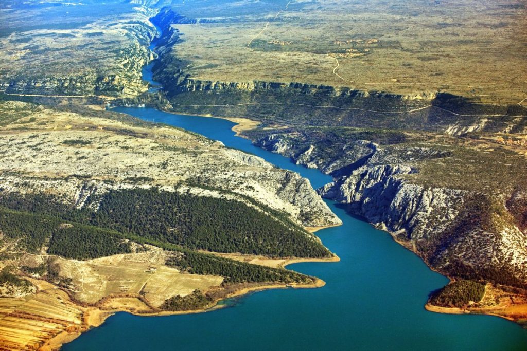
Krka National Park lies within Šibenik-Knin County and covers a total area of 109 km² of the loveliest sections of the Krka River, and the lower course of the Čikola River.


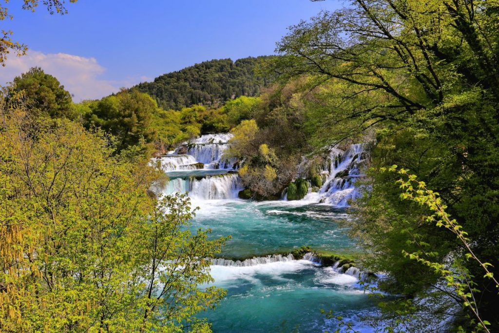
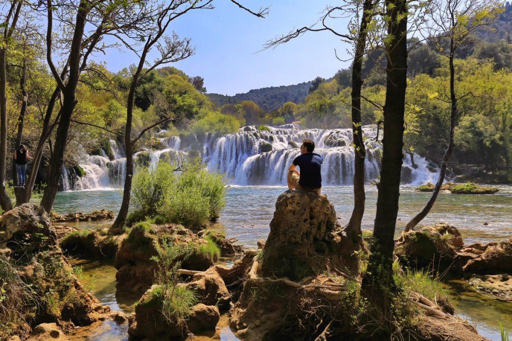
The national park is a vast and primarily unaltered area of exceptional natural value, including one or more preserved or insignificantly altered ecosystems. The purpose of the park is primarily to serve science, culture, education, and recreation, while tourism activities have also been introduced for its visitors.

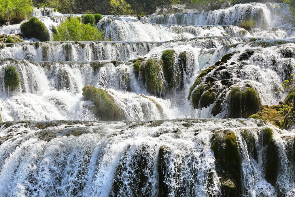
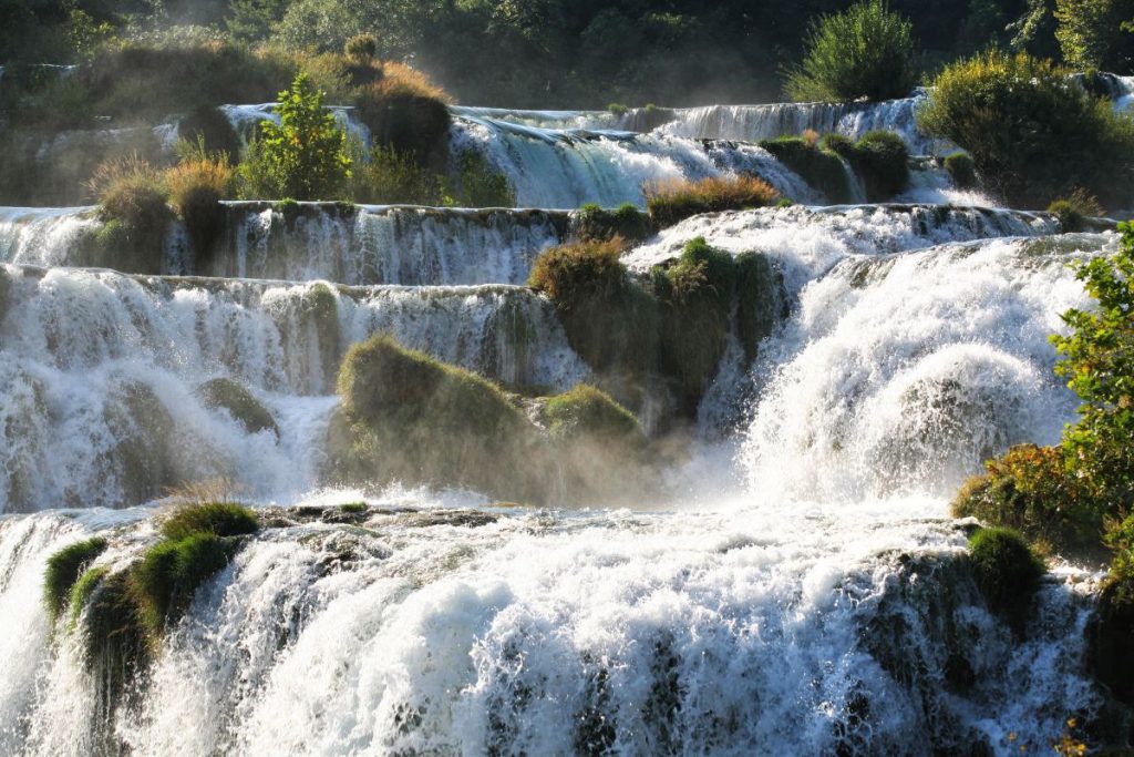
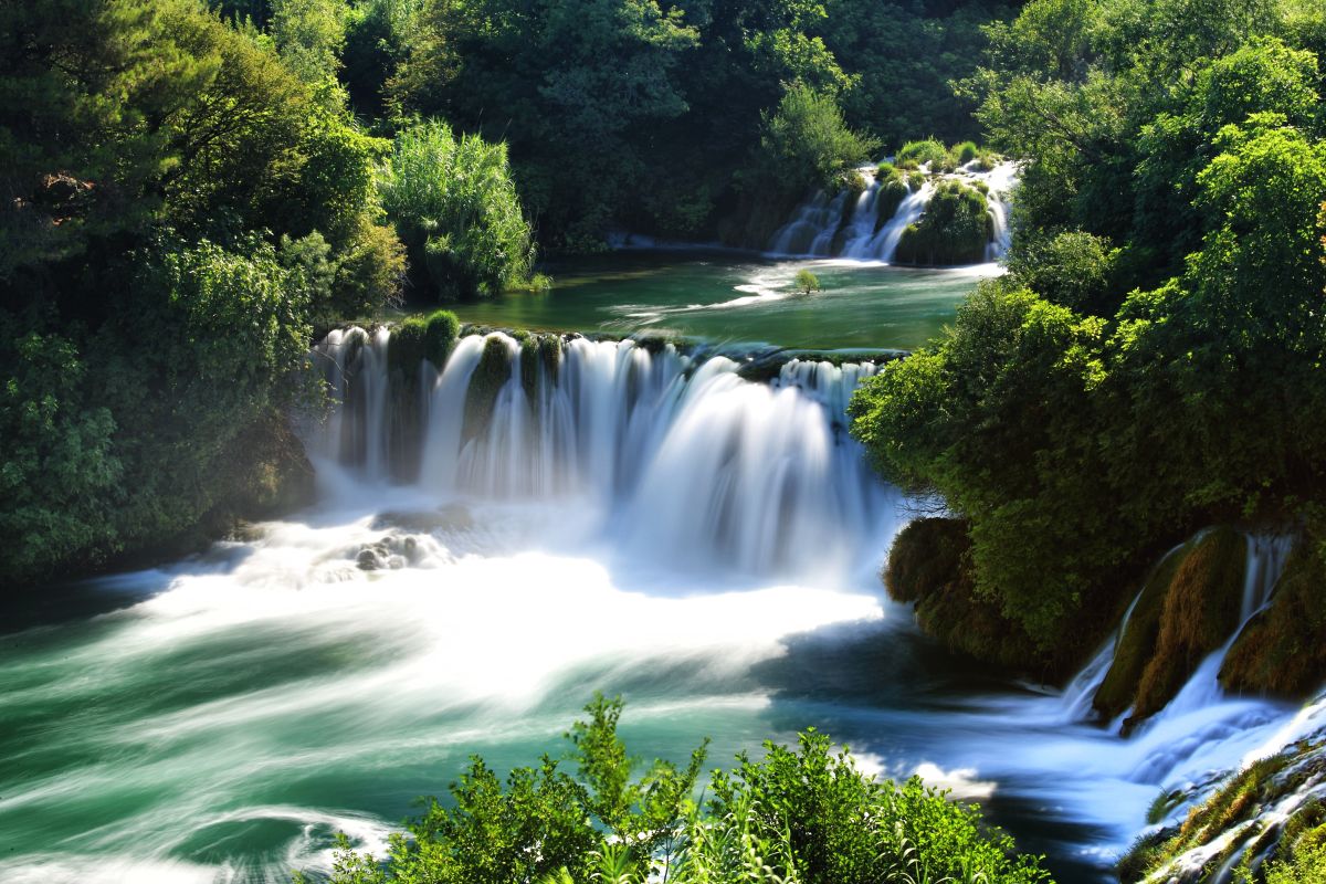
Including the submerged part of the river at the mouth, the Krka River is 72.5 km long, making it the 22nd longest river in Croatia. It springs in the foothills of the Dinara mountain range, 2.5 km northeast of Knin. With its seven waterfalls and a total drop in altitude of 242 m, the Krka is a natural and karst phenomenon. The travertine waterfalls of the Krka River are the fundamental phenomenon of this river.

The need to legally protect the Krka River and its exceptional natural values were already recognized in the mid-20th century. The initiative to proclaim the Krka River a national park was again launched in 1971, with the drafting of a physical plan entitled Krka National Park: physical development plan. On 24 January 1985, the Parliament of the Socialist Republic of Croatia proclaimed the area covering 142 km² from the Early Croatian fortresses of Trošenj and Nečven to the Šibenik Bridge, including 3.5 km of the course of the Čikola River, a national park. Due to four urban centers (Skradin, Bilice, Raslina, and Zaton), the construction of the Zagreb–Split motorway, and the development of tourism and other economic activities in the area, in 1997 the Croatian Parliament revised the park boundaries by passing the Act on Amendments to the Act on the Proclamation of Krka National Park. The southern border of the park was shifted upstream from the Skradin Bridge, and the northern part virtually all the way to Knin. The park boundaries stretch for 50 km along the upper and middle course of the Krka River (two kilometers downstream from Knin all the way to Skradin), and the lower course of the Čikola River (including the confluence and 3.5 km of the river canyon), in the territory of the towns of Knin, Drniš and Skradin, the City of Šibenik, and the municipalities of Ervenik, Kistanje, and Promina.


The seat of the Public Institution of Krka National Park is in Šibenik, at Trg Ivana Pavla II 5, with branch offices in Skradin, Drniš, and Knin.


Krka National Park is managed by the Public Institute, under the jurisdiction of the Ministry of Environmental and Nature Protection of the Republic of Croatia. The activities of the Institute include the protection, preservation, and promotion of the national park, for the purpose of protecting and conserving natural resources, and supervising the implementation of environmental protection measures within the protected area.

The bodies of the Public Institute are the Management Council and Director. The Management Council governs the Institute, while its operations are organized and managed by the Director, who is appointed by the Minister of Environmental and Nature Protection. The Public Institute of Krka National Park is divided into six services and 15 departments that are overseen by the Office of the Director.

Krka Waterfalls

Skradinski Buk

Skradinski Buk is the last seventh, the longest travertine barrier on the Krka river. It is one of the most unusual and beautiful landscapes of the Krka National Park.

It is located about 13 kilometers downstream from the Roško waterfall, or a total of 49 km downstream from the source. The growth of the travertine barrier of the Skradinski Buk caused the water of the Krka River to lake up to Roški Slap and three kilometers of the lower course of the Čikola River, thus creating one of the most unusual and beautiful landscapes of the Krka National Park. The common waters of the Krka and Čikola rivers flow over 17 steps of Skradinski Buk, spread over 800 meters in length. The width of the waterfall is from 200 to 400 meters with a total height difference of 45.7 m. Of the travertine forms in the upper part of the waterfall, we find sills, travertine islands, curtains, and barriers, and in the lower part half caves, caves, and chines. A footpath has been built across the river. During the tour of the path in just 60 minutes of leisurely walking, in the deep shade of lush Mediterranean and sub-Mediterranean vegetation, the visitor enjoys a unique microcosm of magical sounds, light, colors, the mysterious world of travertines and numerous plant species of travertine barriers and water habitats.

A careful visitor will not miss the song of the nightingale, the chatter of the coot, the swimming of the Illyrian chub, the swift movements of the white-eared or diving osprey, the call of the green frog, the flight of the hawk and the playful dance of the emerald dragonflies and colorful butterflies. At the Roško waterfall, here you can see several restored mills, rolling mills, and columns that have been using the power of the water flow for centuries. Respecting traditional architectural values, some mills have been arranged as souvenir shops and taverns, while others have been turned into exhibition spaces for the ethnographic collection. On the left side of the river are the ruins of the first Croatian hydroelectric power plant. The “Krka” hydroelectric plant (later called “Jaruga I.”) was built and put into operation on August 28, 1895, just two days after the first hydroelectric plant on the Niagara River was put into operation. It worked until the First World War when, due to military needs, it was scrapped. Today’s hydroelectric power plant “Jaruga II” was built in 1904.

Skradinski Buk can be reached by road Šibenik-Tromilja-Lozovac or road Knin-Drniš-Tromilja-Lozovac. The entrance to Lozovac is the main road entrance to the Krka National Park. From Skradin, which can be reached by the road Šibenik-Tromilja-Skradin or the road Knin-Drniš-Tromilja-Skradin and by boat from the direction Šibenik canal-Šibenik-Prukljansko Jezero-Skradin to Skradinski Buk, from April to November visitors are transported by boats to the NP “Krka “.

Roški Waterfall

The sixth and penultimate one, Roški Slap, is extremely interesting because of the cascades that the people called Ogrlice, because of the distinctive and rich vegetation, mills and columns, some of which have been restored, and much more.

About 14 kilometers downstream from Miljacka waterfall is Roški waterfall, the sixth and penultimate waterfall on the Krka river. It got its name from the Rog hillfort, whose traces can barely be seen today. In this part, the canyon expands in the shape of a funnel. The beginning of the travertine barrier is made up of a series of small cascades (popularly called Ogrlice), while the middle is made up of numerous backwaters and islets. The length of the barrier is about 650 meters, the greatest width is about 450 meters, and the total height difference is 22.5 m.

The main waterfall is located at the end of the barrier where the Krka falls in a wide fan of 15 m deep into Lake Visovac. Of the travertine formations at the waterfall, we find caves, beards, thresholds, barriers, and cones. The cones appear at the foot of the main waterfall and represent the specificity of the Roški slap. In 1910, the Roški slap hydroelectric power plant was built on the right bank. A road crosses the waterfall since Roman times. On both sides of the river, there are numerous mills, some of which have been restored and returned to their original function. Next to the mills, a tower for processing wool and rollers for washing cloth, which have extreme cultural and historical significance as monuments of rural construction and the economic past, were rebuilt. Considering the primary activity and folk expression, they are also considered ethnological-ethnographic monuments. The Roški waterfall is also extremely interesting because of the distinctive and rich canyon vegetation at the junction of dry, bright, and moist, shady habitats.

The waterfall can be reached from the Promin side via the Drniš-Širitovci road, and from the Bukovac side from the village of Laškovice. From Šibenik, Roški slap can be reached via the road Šibenik – Pakovo Selo – Ključ – Širitovci or via the road Šibenik – Skradin – Dubravice – Rupe – Laškovica. It is also possible to reach Roški Slap by river from Skradinski Buk by excursion boats of the Public Institution Krka National Park.

Miljacka waterfall

On the left bank of the river, at the foot of the waterfalls, there is the “Miljacka” hydroelectric power plant, the largest on the Krka River. Its construction began in 1904, and by 1910 it was the most powerful hydroelectric power plant in Europe.

A kilometer downstream from Rošnjak, squeezed in the river bed between high rocks overgrown with lush sub-Mediterranean vegetation, is the Miljacka waterfall. It consists of three larger and numerous smaller travertine steps with a total height of 23.8 m. The upper part of the Miljack waterfall is characterized by ridges and half-caves, while the lower part is characterized by low thresholds. The waters of the Krka River are joined here by the waters of the Zrmanja River through the source of Miljack. The source is a direct connection between Zrmanja and Krka and is a unique hydrogeological phenomenon. In the dry period, its minimum yield is about 2 m3/s. At the bottom of the falls, on the right bank of the river, there are several collapsed mills and a water intake for Kistanje, and on the left bank is the “Miljacka” hydroelectric power plant. HPP “Miljacka” is the largest hydropower plant on the Krka River. Its construction began in 1904. It was put into operation in April 1906 (the first unit), and in the final scope in 1907. Until 1910, it was the most powerful hydroelectric power plant in Europe. A hundred meters downstream from the waterfall on the right bank of the river is the Miljacka II cave. where numerous endemic and protected underground animals live. Among them, the most attractive is olm or proteus (Proteus anguinus), also called “the human fish”, which is one of the exceptional features of Europe, and the long-legged bat, whose colony of over 4,000 individuals is one of the largest in Europe.

You can reach the waterfalls from the Bukovica side by taking the Knin – Kistanje road if you turn onto the Oklaj – Drniš road and at the first intersection towards the “Miljacka” hydroelectric plant. From the Promin side, the waterfalls can be reached by the road Drniš – Oklaj, if after the village of Puljana you turn towards the “Miljacka” hydroelectric plant. Note: individual visits to the waterfalls are not possible because they can only be reached through the “Miljacka” hydroelectric power station.

Rošnjak waterfall

The people called it the Altar because of its simultaneous primordial simplicity and mystical untouchability. Rošnjak is the lowest Krka waterfall.

A kilometer downstream from the Manojlovac waterfall, where the canyon is getting deeper and narrower, there is, hidden in untouched nature, the lowest waterfall of the river Rošnjak or Sondovjel (Šundovi). It consists of one step about 40 m wide and only 8.4 m high. Among the sedered forms, beards, sub-brackets, and half-caves predominate. It is located in a picturesque canyon squeezed between almost 200-meter-high cliffs.

It is the only waterfall on which, due to inaccessibility, there have never been mills. Although it has not been touched by human hands and is only visible to the eye, in the warm part of the year Rošnjak does not have water that is drained to the “Miljacka” hydroelectric plant. In the period of high water, the waterfall at the bottom of the canyon is surrounded by a noisy mist and captivates with its simplicity and primeval beauty. Because of the mysticism of the scene and its inaccessibility, the people probably called it an altar.

The waterfall can be reached from the Bukovica side on the road Knin – Kistanje if you turn onto the road Oklaj – Drniš and at the first intersection towards the “Miljacka” hydroelectric plant. From the Promin side, the waterfalls can be reached by the road Drniš – Oklaj, if after the village of Puljana you turn towards the “Miljacka” hydroelectric plant.

Manojlovac waterfall

Once the visitor sees this highest and, as many say, the most beautiful waterfall in all its splendor, he will carry it inside as one of the most impressive natural beauties.

Half a kilometer downstream from Brljan, where the river makes a sharp turn, falls the Manojlovac waterfall, the highest and, as many thinks, the most beautiful waterfall of the Krka river. The waterfall consists of a series of travertine barriers with a total height of 59.6 m, with the largest barrier at a height of 32.2 m. The length of the waterfall is about 500 m, and the width is about 80 m.

Of the travertine formations at the waterfall, the most common are the beards, caves, and semi-caves. The canyon around the waterfall is overgrown with rich sub-Mediterranean vegetation, and there are small fields and pastures along the river. The ruins of abandoned mills are visible at the foot of the falls. The waterfall, like Brljan, is dry in the warm part of the year because its water is taken from the reservoir of the nearby “Miljacka” hydroelectric plant. In a period of high water, the waterfall plunges deafeningly into the depths, shrouded in a veil woven in a palette of rainbow colors. Once the visitor sees the waterfall in its magnificent beauty, he will carry it inside him as one of the most impressive natural beauties.

The most beautiful view of the waterfall is from the edge of the canyon on the Bukovica side, a few hundred meters from the Burnum archaeological site, on the Knin – Kistanje road. From the Promin side, Burnum can be reached by the road Drniš – Oklaj, which connects with the road Knin – Kistanje.

Brljan waterfall

It is most beautiful in the spring when the travertine cascades have not yet been covered by lush vegetation.

Two kilometers downstream from Bilušić buk, at the exit from the canyon, Krka expands into 400 m wide and 1,300 m long Ćorića lake (Bjelober, Brljansko lake). The lake was formed in part by the growth of the travertine barrier of the Brljana waterfall, and in major part by the construction of the concrete dam of the Brljan reservoir for the needs of the “Miljacka” hydroelectric plant. The water of the lake overflows over the Brljan waterfall only during high water, because the water is taken to the hydroelectric power plant through a long tunnel.

The length of the travertine barrier of the Brljana waterfall is about 300 m, the width is about 180 m, and the total drop is 15.5 m. There are smaller lakes, rapids, and rapids upstream. The waterfall is surrounded by lush sub-Mediterranean vegetation, small pastures, and cultivated fields. It is most beautiful in the spring when the travertine cascades have not yet been covered by lush vegetation. A road has been crossing through the canyon and over the waterfall since ancient times, as evidenced by the remains of the Roman military camp Burnum on the Bukovac side. Today’s road from Bukovica to Promina also passes over the travertine barrier. Numerous remains of mills are visible on the left side of the river. In the warm part of the year, the waterfall is dry and lifeless, and the nearly half-kilometer-long lakebed of the Krka river between Brljan and Manojlovac waterfalls also dries up.

You can reach the waterfalls from the Bukovica side by taking the Knin – Kistanje road if you turn onto the Oklaj – Drniš road before Burnum. From the Promin side, the waterfall can be reached by the road Drniš – Oklaj, which connects with the road Knin – Kistanje. The road crosses a travertine barrier, and on the approaches on both sides of the river, there are viewpoints from which you can enjoy an unforgettable view of the waterfall and the Ćorića lake.

Bilušića buk

It is the first of seven waterfalls on the Krka River. Even though it has been damaged, it is still very noisy and attractive because it is the only one that is not affected by the energy exploitation of the river’s water.

The first of the seven waterfalls on the Krka river is Bilušića Buk. It is squeezed into a canyon about 16 km downstream from the source, that is, 9 km downstream from Knin, at an altitude of 214 m. The current appearance of the waterfall and watercourse was changed on four occasions by mining to prevent floods in the Knin field (1834, 1895, 1953). and 1954). The interventions lowered the water level of the upstream stream, which caused Lake Bobodol to dry up. Although damaged, the waterfall is still very noisy and attractive today because it is the only waterfall where there is no energy use of the river water.

The total inflow of the Krka flows over it all year round. It consists of two main steps and several intermediate steps over a length of 300 m, with a total height difference of 22.4 m. The width of the waterfall is about 100 m, but for low water levels, the water overflows through a cut only thirty meters wide. Of the travertine forms of Bilušić, beech is abundant with ridges and half-caves. Downstream from the waterfall, we find numerous barriers, and directly below them travertine thresholds and islets. Outside today’s watercourse, you can see the well-preserved and extremely attractive “dead tufa”.

There is a small lake between the travertine steps. Downstream from the lower step, the river widens and the flow calms down. The waterfall is surrounded by lush sub-Mediterranean vegetation and dense willows. Along the course of the river are several small fields where vegetables are planted. Of the numerous mills, pillars, and rolling mills, only two mills and one rolling mill have been preserved at the waterfall today.

The waterfall can be reached from the Bukovica side on the Knin-Kistanje road if you turn off at the village of Radučića (Omčikus) and continue along the unpaved road to the Radučić railway station. To get to the edge of the canyon, you have to walk a few hundred meters more. From the edge of the canyon, a narrow path leads down to the river at the foot of the waterfall. From the Promin side, the waterfall can be reached by the road Drniš – Oklaj, if you turn off near the village of Gornji Čitluk and continue along the road to the village of Ljubotića and on the unpaved road to the edge of the canyon, from where you have to walk for ten minutes to the waterfall.